|
The following Garmin MVUM
contains data for Sawtooth
National Forest MVUM, Boise National Forest MVUM, Cariboug-Targhee
National Forest MVUM and the Salmon National Forest MVUM.
Download:
Windows Version
Mac Version
Garmin Montana Screenshot
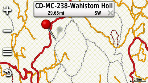
The screenshot shown above also
has my Roads and ATV Trails map
enabled.
Key: Motorcycle trails =
Dark\Light Gray dashed lines. Red = Main roads, Orange =
Roads, Red\Black dashed lines = ATV trails.
Release notes:
1. These maps were updated on
August 16, 2014.
Legal stuff:
The forest service didn't make
the map. Don't complain to them if something is screwed
up. Always compare this map to the official MVUM to make
sure I didn't screw something up. Always have a current
paper copy of the MVUM with you while riding. I make no
guarantee as to the accuracy of any of the data in the map.
Sawtooth Forest:
-
Data extracted from the
Idaho Trails website
several years ago and compared against the
ERSI shape file provided by the Region 4 Geospatial Data
site.
-
All data verified again the official
MVUM - I'm human and there might be mistakes though.
Boise National Forest:
-
Data originally acquired from the
Idaho Trails
website and migrated into Basecamp, but I recently deleted
the data and started over with new data extracted from the
ERSI shape file provided by the Boise National Forest.
-
All data verified again the official
MVUM - I'm human and there might be mistakes though.
Caribou-Targhee National Forest:
-
Data extracted the Caribou-Targhee
geodatabase and then processed by
My Geodata
Converter. Data was then dumped into Garmin
Basecamp and then sorted by forest location, files named
after comparing the track with the MVUM and the
Idaho Trails website.
Data may contain errors such as wrong trail numbers due to
typo errors. I would have used the ERSI Shape File,
but the data has not been provided by the Forest Service
yet. When I am able to get the data, I will tag the
roads appropriatly.
-
All data verified again the official
MVUM - I'm human and there might be mistakes though.
Salmon-Challis National Forest
-
Data extracted the Caribou-Targhee
geodatabase and then processed by
My Geodata
Converter. Data was then dumped into Garmin
Basecamp and then sorted by forest location, files named
after comparing the track with the MVUM and the
Idaho Trails website.
Data may contain errors such as wrong trail numbers due to
typo errors. I would have used the ERSI Shape File,
but the data has not been provided by the Forest Service
yet. When I am able to get the data, I will tag the
roads appropriatly.
-
All data verified again the official
MVUM - I'm human and there might be mistakes though.
Payette National Forest
- No ERSI Shape File data available. When it is, I
will include this forest on the map as well.
Directions
-
Download the file you need.
-
Run the Windows executable and
follow the directions to install it. On the Mac file,
open the ZIP file and do whatever you normally do (I don't
have a Mac at home, sorry)
-
Open BaseCamp, and in your map list
you find it in the list of map products.
-
Now, once the map is in BaseCamp,
transfer it to your GPS like you would transfer any map to
it (inside BaseCamp, go to Maps - Install Maps, etc...)
-
If you download and install a newer
version of this map in BaseCamp, you also have to transfer the
new map to your GPS. I would suggest deleting the map
from the GPS and then reinstall the new one.
|