|
The following Garmin map
contains data for a good chunk of the State of Idaho.
Download:
Windows Version (11-14-22)
Mac Version (6-7-20)
version 3 for now
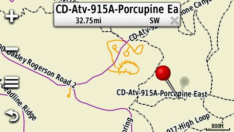
Garmin Montana Screenshot
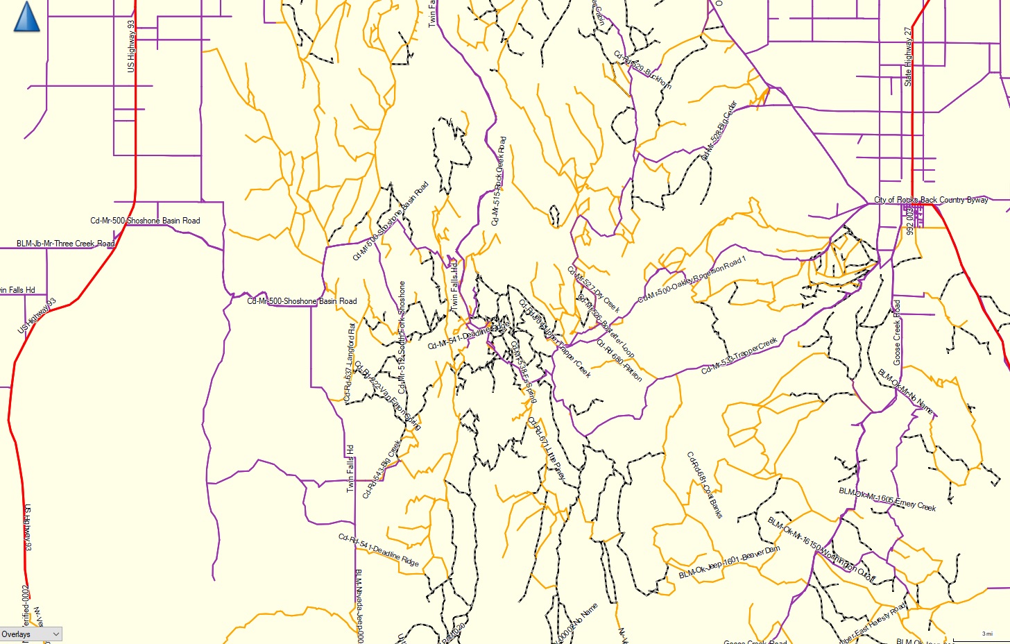
Basecamp Screenshot of the
Cassia Division
&
North Canyon Park
Key for both a Garmin Montana,
as well as Basecamp:
-
Red = Interstates, state
highways, US Highways, Idaho Byways.
-
Blue = Public roads or other
paved roads through the BLM\Forest Service lands.
-
Orange =
Roads that would be considered a narrow dirt road that would be
suitable for a jeep.
-
Red\Black dashed lines = ATV trails
or roads that could be considered a ATV trail.
Release notes:
1. These maps were updated on
November 14, 2022.
2. This map contains:
A. Idaho Interstates, state
highways, us highways, Idaho Byways, and many public roads in
many highway districts through the state. Unfortunately,
not all road districts are represented.
B. Roads and atv trails from the
following forests: Boise, Sawtooth, Caribou-Targhee,
Humboldt, Payett, Salmon, and Sawtooth forests.
Roads\Trails are named with the forest division first, road\trail
type next, followed by the road number and name. Example:
CD-ATV-868-Little Piney Access would be in the Cassia Division
of the Sawtooth forest, is an ATV trail, and is trail 868 Little
Piney Access.
C. BLM roads and trails in a good
chunk of Southern Idaho, Northern Nevada, and Northern Utah.
Most of these roads\trails
were exported from the Idaho Trails data, then hand traced when
they did not overlay the actual road accurately. I also
hand traced all other roads on BLM land.
Most roads are
un-named, so they are named sequentially.
If a road has a
"MR" prefix, it is either paved or dirt, but wide enough and in
good enough shape to be vehicle safe.
Anything with a
"Jeep" prefix looked wide enough and in good enough shape for a
jeep or beat up truck to go on.
Anything with an "ATV" or "UTV"
prefix is just that, probably good enough for an ATV or UTV to go on.
Example: BLM-CM-ATV-00001-No Name would be a ATV trail on
BLM ground in the Craters of the Moon area.
BLM-CM-ATV-3209-North Pagari Road would be a BLM road in the
Craters of the Moon area, that doesn't get much use so I
consider it an ATV trail. It is road 3209 and it's name is
North Pagari Road.
Legal stuff:
The forest service didn't make
the map. Don't complain to them if something is screwed
up. Always compare this map to the official MVUM to make
sure I didn't screw something up. Always have a current
paper copy of the MVUM with you while riding. I make no
guarantee as to the accuracy of any of the data in the map since
I have never ridden most of the roads and trails. You get
a ticket, it is your fault, not mine.
Directions
-
Download the file you need.
-
Run the Windows executable and
follow the directions to install it. On the Mac file,
open the ZIP file and do whatever you normally do (I don't
have a Mac at home, sorry)
-
Open BaseCamp, and in your map list
you find it in the list of map products.
-
Now, once the map is in BaseCamp,
transfer it to your GPS like you would transfer any map to
it (inside BaseCamp, go to Maps - Install Maps, etc...)
-
If you download and install a newer
version of this map in BaseCamp, you also have to transfer the
new map to your GPS. I would suggest deleting the map
from the GPS and then reinstall the new one.
|